スコットランド2200km走破 エディンバラ城の歴史1 Edinburgh Castle 青山貞一 Teiichi Aoyama 池田こみち Komichi Ikeda 2018年10月30日公開予定 独立系メディア E-Wave Tokyo 無断転載禁 |
| スコットランド総目次へ エディンバラ城 城の歴史1 城の歴史2 城の歴史3 城の歴史4 城の歴史5 城の歴史6 エディンバラ城に入る 外部防御 ポートクリス門とアーガイル塔 聖マーガレット教会堂 王冠広場と王室 国立戦争記念館 グレートホール ◆エディンバラ城の歴史1  ディンバラ旧市街にそびえ立つエディンバラ城 source:Wikimedia Commons ここではエディンバラ城だけでなく、エディンバラ地域の歴史を有史以前に遡り紹介しましょう。 ・有史以前の城の岩 地質 城は、石炭紀の前期(3億4千5百万年前から3億1千万年前まで)中に隆起したと推定される、死火山の岩栓の上に立っている。キャッスル・ロックは火道の遺跡で、冷却する前に周囲の堆積岩を削り取って、玄武岩の一種である非常に硬い粗粒玄武岩(ドレライト)を形成します。 その後の氷河侵食は、ドレライトの抵抗によって、軟らかい岩が東側に残されて、岩と尾の形成を残しました。 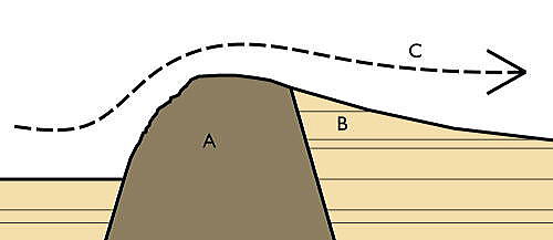 Diagram of a crag and tail feature, such as the Castle Rock: A is the crag formed from the volcanic plug, B is the tail of softer rock, and C shows the direction of ice movement. In the case of Edinburgh, the castle stands on the crag (A) with the Royal Mile extending along the tail (B) Source:Wikimedia Commons キャッスルロックの頂上は標高130メートル(430フィート)で、南西には岩の多い崖があり、周囲の景観を作り出す地盤から80メートル(260フィート)の高さに隆起しています。 これは、城への容易にアクセスできるルートが、尾根がより緩やかに傾く東にしかないことを意味します。 そのような場所の防衛上の利点は自明なのですが、他方、玄武岩は極めて不浸透性であるため、岩石の地質学上の特徴から難しい面もありました。 城の上部区に水を供給することは課題であり、28メートル(92フィート)の深さの井戸にもかかわらず、例えば1573年のラング包囲中に、しばしば水の供給が逼迫したり干上がったりしていました。 ・最古の居住 考古学的調査では、キャッスルロックが人間の住居の場所として初めて使用された時期について、まだ明確にされていません。アグリコラ将軍が1世紀末に北部ブリテン島を侵略している間、ローマがこの地に興味を持っていたとする記録はありません。 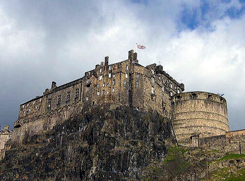 The castle is built on a volcanic rock, as seen here from the West Port area Source:Wikimedia Commons プトレマイオスの2世紀の地図は、ヴォーテディーニ領の「Alauna」という名前の定住地があり、それは「岩石の場所」という意味であることから、これはおそらくキャッスルロックの最も初期の名前である可能性があります。しかし、これはこの地域の部族の丘の砦の別のものを指す可能性もあります。 スコットランド史の初期の原典であるアンドリュー・ウィンタウン(1350〜1420)のオリジナルの記録では、“エブラウス(エブラキゥス)”と呼ばれる伝説のブリトン人の王がエディンバラを建設したとされています。より古い年代記を書いた、ジェフリー・モンマス(1100−1155)によれば、エブラキュウスは20人の妻に50人の子供を抱え、 "Kaerebrauc"(ヨーク)、 "Alclud"(ダンバートン)、 "Maidensの城”を築いたとされています。 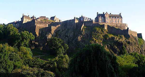 The Castle seen from the North Source:Wikimedia Commons 16世紀の英国人作家、ジョン・ストウ(1525−1605)は、989年にエブラスカスが「エデンブラと呼ばれる乙女の城(メイデン・キャッスル)」を建てたことを賞賛しました。 "Maidens'Castle"(ラテン語:CastraまたはCastellum Puellarum)という名前は、16世紀まで頻繁に現れます。その理由は分かっていませんが、デヴィッド1世の勅許状(1124-1153)とその継承者たちの時代にも見られます。 ウィリアム・カムデンのブリテンについての調査であるブリタニア(1607)によると、「ブリテン人は【Wing Rock 翼の岩】と呼び、スコットランド人は、メイデンズ・キャッスル、そしてヴァージン・キャッスルと呼び、古代、ピクト人の王室の血を引く若い乙女たちがと閉じ込められていたい場所 」とされていました。 ・Earliest habitation Archaeological investigation has yet to establish when the Castle Rock was first used as a place of human habitation. There is no record of any Roman interest in the location during General Agricola's invasion of northern Britain near the end of the 1st century AD. Ptolemy's map of the 2nd century AD[10] shows a settlement in the territory of the Votadini named "Alauna", meaning "rock place", making this possibly the earliest known name for the Castle Rock.[11] This could, however, refer to another of the tribe's hill forts in the area. The Orygynale Cronykil of Andrew of Wyntoun (c. 1350 ? c. 1423), an early source for Scottish history, names "Ebrawce" (Ebraucus), a legendary King of the Britons, as having "byggyd [built] Edynburgh".[12] According to the earlier chronicler, Geoffrey of Monmouth (c. 1100 ? c. 1155), Ebraucus had fifty children by his twenty wives, and was the founder of "Kaerebrauc" (York), "Alclud" (Dumbarton) and the "Maidens' Castle".[13] The 16th-century English writer John Stow (c. 1525 ? 1605), credited Ebraucus with building "the Castell of Maidens called Edenbrough" in 989 BC.[14] The name "Maidens' Castle" (Latin: Castra or Castellum Puellarum) occurs frequently up until the 16th century.[15] It appears in charters of David I (r. 1124?1153) and his successors,[16] although the reason for it is not known. William Camden's survey of Britain, Britannia (1607), records that "the Britans called [it] Castle Myned Agned [winged rock], the Scots, the Maidens Castle and the Virgins Castle, of certaine young maidens of the Picts roiall bloud who were kept there in old time".[17] According to the 17th-century antiquarian Father Richard Hay, the "maidens" were a group of nuns, who were ejected from the castle and replaced by canons, considered "fitter to live among soldiers".[18] However, this story was considered "apocryphal" by the 19th-century antiquarian Daniel Wilson and has been ignored by historians since.[19] The name may have been derived from a "Cult of the Nine Maidens" type of legend. Arthurian legends suggest that the site once held a shrine to Morgain la Fee, one of nine sisters.[20] Later, St Monenna, said to be one of nine companions, reputedly invested a church at Edinburgh, as well as at Dumbarton and other places.[21] Similar names are shared by many other Iron Age hillforts and may have simply described a castle that had never been taken by force[22] or derived from an earlier Brittonic name like mag dun.[23][24] An archaeological excavation in the early 1990s uncovered evidence of the site having been settled during the late Bronze Age or early Iron Age, potentially making the Castle Rock the longest continually occupied site in Scotland.[25] However, the extent of the finds was not particularly significant and was insufficient to draw any certain conclusions about the precise nature or scale of this earliest known phase of occupation.[26] The archaeological evidence is more reliable in respect of the Iron Age. Traditionally, it had been supposed that the tribes of central Scotland had made little or no use of the Castle Rock. Excavations at nearby Dunsapie Hill, Duddingston, Inveresk and Traprain Law had revealed relatively large settlements and it was supposed that these sites had been chosen in preference to the Castle Rock. However, the excavation in the 1990s pointed to the probable existence of an enclosed hill fort on the rock, although only the fringes of the site were excavated. House fragments revealed were similar to Iron Age dwellings previously found in Northumbria.[27] The 1990s dig revealed clear signs of habitation from the 1st and 2nd centuries AD, consistent with Ptolemy's reference to "Alauna". Signs of occupation included some Roman material, including pottery, bronzes and brooches, implying a possible trading relationship between the Votadini and the Romans beginning with Agricola's northern campaign in AD 82, and continuing through to the establishment of the Antonine Wall around AD 140. The nature of the settlement in this period is inconclusive, but Driscoll and Yeoman suggest it may have been a broch, similar to the one at Edin's Hall near Duns in the Scottish Borders.[28] |